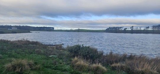
Crookfoot Reservoir
This is an easy circular (moderate in two places) route of 8.5 miles. We set out from the Wynyard Woodland Car Park and cross over the road bridge and head towards Embleton Farm. Just before reaching the farm, we pass the once medieval settlement of Swainston only now recognisable by embankments. From thereon we pass the abandoned Ambleton Church that was previously used by around 86 parishioners. Heading steeply up hill for 100 meters we follow the well used PROW to Amerston Hall Farm. Shortly afterwards we walk alongside the Crookfoot Reservoir where an abundance of wild birds have made their habitat. The area surrounding the reservoir is quite pretty. Continuing along the PROW we eventually reach Beacon Hill Farm along a very minor B road. Turning left towards Pawton Hill Farm, we shall stop here to have a spot of lunch and say farewell to the five mile group. Moving towards the wood we cross over a well maintained stream bridge and it is here that the track disappears. We will then meander our way up the hill for about 100 meters through thicket until we find the way marker and stile that leads us to Cole Hill Farm. The PROW routes through the centre of the farm and the gate was locked at the time of the recce. However, an easy to climb farm gate will not stop us!
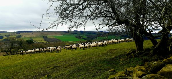
Rambling through some lush green fields and a few dodgy stiles we then reach Embleton Moor where and abundance of inquisitive sheep are grazing.
"The Norh Wind Doth Blow Here" so make sure you are wrapped up warm. On reaching Embleton again there is yet another medieval settlement but hidden by the high hedge. Continuing towards the Castle Eden Walkway we eventually turn left and back to our start point.
For the first five miles the going is very easy along gravel paths with the occasional muddy parts. For the longer walking group, it may be a bit muddy crossing the Embleton Moor.
Dave Marshall has kindly agreed to look after the five mile walkers.
Please Note: The weather forecast for the 11th is 3c and a gentle breeze. Sleet or snow is expected. Notwithstanding severe snowfall the roads to the start point should be relatively clear - we shall see. However please wrap up warmly and ensure sufficient hot drinks etc are taken along.
Directions from Chester le Street:-
Take the A1 motorway south. Take exit 60 towards Teesside (A689) Continue along the A689 and over two roundabouts for approx 6.5 mile. Continue under the dual carriageway suspension bridge which is unmissable. At the next roundabout turn back along the carriageway towards Durham and on meeting the bridge again the car park is on the left.