Great walks on Ministry of Defence land
Inspiring walks in hidden corners of Devon, Pembrokeshire and Edinburgh.

Experience walking on Ministry of Defence land
We’ve partnered up with the Ministry of Defence (MOD) to highlight a series of walks that will take you into hidden corners of Devon, Pembrokeshire and Edinburgh.
Castlelaw, Edinburgh
Castlelaw is a hill that rises steeply from the valley to the northern tops of the Pentland Hills in Midlothian, Scotland. It is best known for the Iron Age hill fort on its slopes. When it was occupied, the site consisted of three earthwork ramparts, ditches and timber palisades. The fort also contained a souterrain for the storage of agricultural produce.
The fort commands views over the Forth and Lothian. Traprain Law and Berwick Law, both significant centres of power in the Iron Age, are also visible from the site.
The fort is maintained by Historic Environment Scotland as a scheduled monument.
Location
The military training area comprises Castlelaw Ranges and Dreghorn Dry Training Area. Castlelaw Ranges are situated on the south side of Castlelaw Hill. Dreghorn Dry Training Area extends from the Edinburgh City By-Pass at Dreghorn Mains to Flotterstone and from Bonaly Reservoir to Fulford.
The highpoints of the training area give stunning views across the city, the Firth of Forth and on a clear day the Highlands beyond. The area is home to some rare habitats and wildlife including small numbers of black grouse.
Historical features of Castlelaw
Surveys commissioned by the MOD have recorded numerous heritage sites on the training area, with perhaps the most impressive being the spectacular Castlelaw Iron Age Hill Fort on the southwestern edge of the Range.
Castlelaw Fort is a multi-ramparted Hill Fort that was probably built around the middle of the first millennium BC and used for several hundred years. Two archaeological excavations, in 1931/2 and 1948, have shown that the initial fort was defended by a single palisade trench and a single rampart. The external ramparts and ditches were added later, producing a multi-ramparted fort in its final phase. The fort itself measures about 150m long and 100m wide overall, with an interior some 90m long by 37m wide. Breaks in the ramparts suggest that there were three entrances, one at each end and one in the middle of the south side.

When the fort was largely abandoned, perhaps in the 2nd century AD, a stone-lined souterrain, or underground passage, was built into the ditch near the east entrance. The souterrain at Castlelaw is one of relatively few souterrains south of the River Forth. The main curved gallery is 21m long with a small stone chamber on its west side, reached by a short passage. The souterrain was probably roofed with timber and earth and may have been associated with structures on the ground surface above. The purpose of the souterrain is uncertain but it has been suggested that they were used for storing grain or perhaps served as a refuge in times of threat. Finds from the feature were all of Roman origin and from the 2nd century AD. They included an enamelled bronze brooch, glass bottle fragments and Samian pottery.

On a prominent knoll only 100m northeast of the Castlelaw Fort, there are the faint remains of a prehistoric palisaded enclosure called Castle Knowe.
A system of practice trenches can be found immediately northwest of Castle Knowe, likely from around the time of the First World War. Enclosing a roughly square area up to 120m across, the trenches are now visible as hollows little more than 1m in breadth and 0.2m in depth.

A particularly prominent type of earthwork called rig and furrow, characteristic of early agricultural ploughing and dates from the medieval period through to the 19th century.

Three walks at Castlelaw
Castlelaw Hill Circular
A 4.7km (2.9 mile) walk that takes in the Castlelaw Hill Fort and Subterrain before skirting all the way around Castlelaw. Returning to the car park at Castlelaw.
Castlelaw & Capelaw Circular
A 9.4km (5.8 mile) route that again passes by Castlelaw Hill Fort and souterrain before heading north towards Edinburgh. It drops down to the Dreghorn side of the Training Area before returning via the side of Capelaw. This route also skirts Castlelaw to return to the starting point at Castlelaw car park.
Castlelaw Dreghorn Circular
A 13.2km (8.2 mile) loop from Castlelaw Car Park heading north to Dreghorn via Chuckie Knowe, returning via Capelaw and Harbour Hill. The route heads off the MOD estate into the wider Pentland Hills Regional Park towards Maidens Cleuch and joins the quiet public road that runs alongside Glencorse reservoir. The route then follows a path back onto MOD land that returns you to the Castlelaw car park.
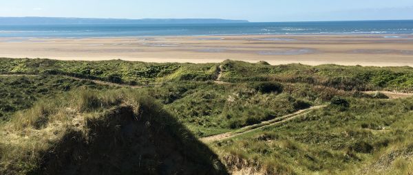
Braunton Burrows, Devon
Braunton Burrows is one of the largest sand dune systems in the British Isles. It lies at the heart of the North Devon Area of Outstanding Natural Beauty (AONB) and a UNESCO designated Biosphere reserve. It is home to an abundance of flowers, plants and wildlife.

Location
Braunton Burrows is located to the north of the Taw and Torridge estuary and flanked by Saunton Sands, a stretch of sandy beach. Recognised as a Site of Special Scientific Interest, Braunton Burrows is a wild expanse, approximately 1,000 hectares in size.
Braunton Burrows is owned and managed by Christie Devon Estates in conjunction with Natural England. Both work closely with key stakeholders (including the North Devon Coast and the UNESCO North Devon Biosphere Reserve) to manage and conserve this range of stunning dune habitats.

The Second World War
Braunton Burrows played an important role in the Second World War and continues to be used by the military. The landscape provides realistic desert driving conditions and a challenging environment to navigate through. The coast also allows for beach landing rehearsals as well as the occasional aircraft landing.

While the presence of vehicles may appear counter-intuitive on a site of ecological interest, controlled use to churn up pathways and brush can make a positive contribution by clearing space for rarer flowers and plants to grow.
Walking around Braunton Burrows
The dunes at Braunton Burrows are deceptively extensive. The Braunton Burrows guide will help you navigate around the site. It provides an aerial view, as well as two walks across the dunes, set within lots of site information. Both walks take about an hour and a half and show off the history, ecology and all-round beauty of the site.
The history walk, located to the south of the site, highlighted in blue on the aerial view, can be enhanced with this audio tour.
Braunton Burrows guide
A guide with two walks around Braunton Burrows, Devon.
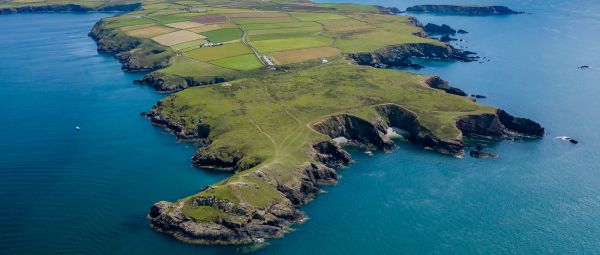
Castlemartin, Pembrokeshire
Castlemartin is a spectacular coastal landscape, on the west coast of Pembrokeshire within the Pembrokeshire Coast National Park.
Location
Castlemartin is six miles south of the town of Pembroke and covers about 2,390 hectares.

A preserved coastal landscape
A beautiful area designated as a Site of Special Scientific Interest, Castlemartin contains a wide variety of flora, as well as some of the finest limestone coastal scenery in the National Park. Castlemartin Range is remarkable for its history, wildlife and geology, including fossil records of international significance.
Castlemartin has been preserved as a spectacular coastal landscape, and the MOD manages its special heritage to preserve it for future generations.
Castlemartin Range is also an important cliff climbing area and climbers come from across the UK and abroad to scale the sea-battered cliffs.

The history of military activity at Castlemartin
Castlemartin has a long history of military activity. Today it is the premier Armoured Fighting Vehicle live firing range in the United Kingdom, providing essential training for our soldiers. The facility is mainly used for so-called ‘mounted’ and ‘dismounted’ (i.e. in-vehicle and on foot) field firing; but when such exercises are not taking place it is also used for dismounted ‘dry’ training (i.e. without live firing). It is also used by civilian organisations and research establishments.
The military’s presence on Castlemartin has meant that the range has not been intensively farmed for over 70 years. A collaborative working partnership between the DIO, Pembrokeshire Coast National Park and Natural Resources Wales ensures that the site is managed sensitively allowing wildlife to flourish.
Checking firing times
Despite being a live range, there are opportunities to enjoy and explore this fabulous coastline. Check the live firing times calendar before making your visit. Even when the Range is live, the Castlemartin Range Trail allows walkers safe access along the Range boundary between Bosherston and Freshwater West.
Three walks around Castlemartin
To help you get the most out of your visit here are three walks, each offering different insights into this fantastic, varied location:
St. Govan’s Head loop
This 2.8 km / 1.7 mile trail links St Govan’s Chapel with the St Govan’s Headland. It introduces you to some of the amazing features found on the Range with the aid of a series of interactive points. Be aware that the stairs down to St. Govan’s Chapel are steep and can be slippery when wet.
Stack Rocks to St. Govan’s Head
Using the local Coastal Cruiser bus, this can either be a one-way 5 km / 3.1 mile walk or for those feeling a little more energetic, you could walk there and back.
Range East Circular
Using the Pembrokeshire Coast Path and the Castlemartin Range Trail, this 15km / 9.3 mile hike links Stack Rocks, St. Govan’s Head and Bosherston village, as well as the pleasant rural boundaries of the Range.
Walking on military land
Some military land is open to the public when it is not being used for training. It’s important to know how to walk safely when exploring military land.

10 best dog walks
Great places to explore with your four-legged friend, from thrilling heights and fantastic forests to sweeping beaches.
Ultimate guide to coastal walks in Pembrokeshire
Enjoy some of Britain’s most spectacular shoreline trails on the Pembrokeshire Coast Path and surrounding national park.