The ultimate guide to hiking Tryfan and the Glyderau
Our guide to planning a safe and enjoyable hike
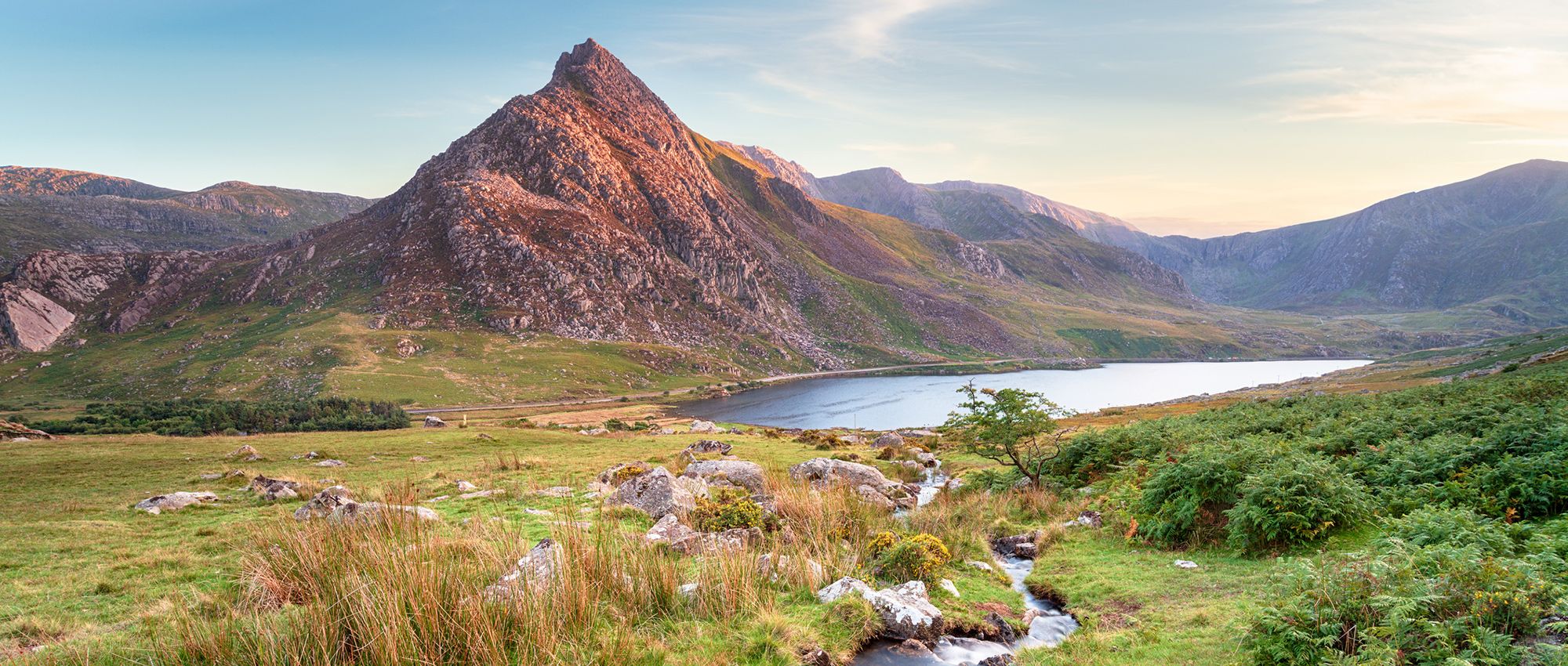
What and where is Tryfan?
Looking for a challenge in north Wales? At 917.5m, Tryfan offers a wonderful adventure for intrepid walkers drawn to its distinctive, dinosaur-spine ridge of volcanic rock. To the west and south stretches a scalloped crescent of crags reaching 1001m at Glyder Fawr. This range of peaks, the Glyderau, includes four of the ten tallest ‘washis’ (Welsh hills over 600m with at least 50m drop all around).
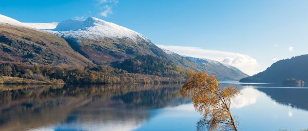
You’ll find rare plants and feral goats among these spectacular mountains, plus ravens and peregrine falcons. There are several gorgeous mountain lakes, too. Among the most beautiful is Llyn Idwal, centrepiece of Cwm Idwal National Nature Reserve, Wales’ oldest. At the northern edge is Llyn Ogwen. According to legend, this lake is the last resting place of King Arthur’s sword, Excalibur.
The Glyderau range rises north of Yr Wyddf (Snowdon) between Llanberis, Capel Curig and Bethesda. You can access these dramatic mountains along trails from the south at Pen-y-Pass or Nant Peris, or from the southern shore of Llyn Ogwen. The entire group, sitting just north of Eryri (Snowdonia) National Park, offers breathtaking views and almost endless options for hiking.
Transport and accommodation
There are car parks at Pen-y-Pass (pre-booking essential) and Nant Peris in the south, and at the western end of Llyn Ogwen, plus two large laybys farther east along the A5. Parking spots typically fill early, particularly at Pen-y-Pass, which is also the starting point for popular routes up Snowdon/Yr Wyddfa.
For the southern approach, use the excellent Snowden Sherpa bus services, which run roughly April to September along the A4086 past Pen-y-Pass and Nant Peris from various towns. In the north, an electric bus links Bethesda with Llyn Ogwen. There’s also a bus between Bangor and Corwen via Bethesda, Llyn Ogwen, Capel Curig and Betws-y-Coed. For the latest information, check the Visit Eryri (Snowdonia) website.
For accommodation, YHA Idwal Cottage is an excellent eco-friendly hostel with dorms, private rooms, a hut and camping at the western end of Llyn Ogwen. To the east, Gwern Gof Isaf offers camping, a bunkhouse and other accommodation. This area also provides access to the Carneddau range to the north.
YHA has another hostel at Pen-y-Pass, and you’ll find places to stay in the surrounding region and nearby towns and villages. These include Bethesda to the north, Capel Curig to the east and Llanberis to the west. In all cases you’ll need to book well in advance in summer.
Need to know
Summiting Tryfan means getting your hands dirty. Some scrambling is required whichever route you take. Though the two main ridge routes, North and South, and West Face are not technical climbs, they do call for a head for heights, a reasonable level of fitness and ideally some scrambling experience.
Check the weather forecast before starting off. These rocky trails can be slippery after rain, and wind can make scrambling along narrow ridges testing. Snow makes this very much more difficult, possibly requiring crampons and other technical equipment. Whatever the weather, be realistic about your ability to cope with challenging conditions.
Mist and cloud can descend rapidly in the mountains, so confident navigation is essential. Ensure your phone is fully charged (ideally in a waterproof case), but don’t rely solely on phones or GPS units. Always carry a map and compass. Before setting out, let someone know where you’re going and when you expect to be back.
Bring a waterproof jacket and over-trousers, sturdy worn-in waterproof boots and good socks. Merino socks are best. Wear a quick-drying base layer, and bring warm mid- and outer layers, gloves and a hat. Also pack a torch, whistle, water and food. A survival bag or blanket is a good idea, as well as a basic first aid kit. For more useful tips, you can find useful advice for hikers on the Adventure Smart website.
The summit of Tryfan is dominated by the twin monoliths known as Siôn a Siân (Adam and Eve). You may see peak-baggers hopping across the 1.2m gap between these two 3m-tall rocks. Be warned: there’s a sheer drop, and you’re a long way from medical assistance.
ROUTES
Tryfan’s North Ridge
From the easternmost A5 layby on Llyn Ogwen’s southern shore, skirt beneath the cliff known as Milestone Buttress. Then ascend onto the North Ridge and continuing up and south to reach the summit. Keep an eye out for the Cannon, a distinctive horizontal rock. The ascent involves long, steep stretches of scrambling between rocks using your hands. It’s only about 0.7 map miles, but allow up to two hours. Less-experienced scramblers might consider joining a guided group.
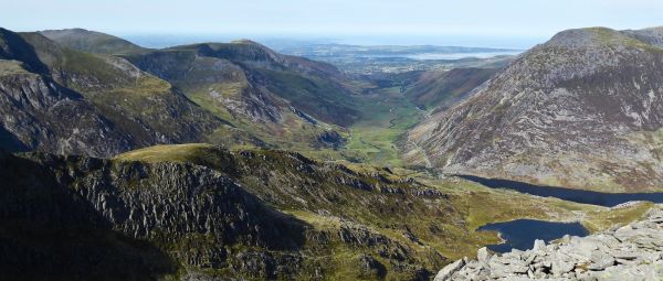
Having admired the views north to the Carneddau and south towards the Glyders and Yr Wydff (Snowdon), there are various options for returning to Llyn Ogwen. Descending past Far South Peak to the pass at Bwlch Tryfan, you can swing right down Cwm Bochlwyd along the Cambrian Way, skirting Llyn Bochlwyd to reach Ogwen Cottage at the western end of the lake. The route is about 2.5 miles altogether. Or continue on to Glyder Fach and choose one of the descent routes described below.
Tryfan’s West Face
From the small carpark on the A5 (shown as a car park on the OS map, as a walled enclosure) located to the west of Ogwen cottage. From here you can head south towards Llyn Bochlywd. Follow this until just before Bochlwyd Buttress. At this point a vague track to the left leads steeply uphill towards Tryfan's West Face. This track becomes more defined as you gain height, and is then easy to follow onto the North Ridge, almost to the summit. The route is strenuous, but the scrambling is easier than other routes. The track is not shown on the OS map.
Tryfan’s South Ridge
Approaching Tryfan’s summit along the South Ridge from Bwlch Tryfan is a little less demanding than the northern route. It still involves some scrambling, though, particularly on the final step to the summit. There are several ways to reach Bwlch Tryfan for Far South Peak and the start of the ridge proper from the north. From Llyn Ogwen, you can ascend along the Cambrian Way through Cwm Bochlwyd from Ogwen Cottage.
Alternatively, start beneath Milestone Buttress, but continue around the northern end of the ridge and instead follow the easier Heather Terrace path beneath the eastern flank. Be ready for a short exposed scramble up to Bwlch Tryfan. You can also reach this point via Cwm Tryfan from Pont Wern-gof, farther east along the A5.
Having reached the summit from the south, return to the bottom of the same ridge and return to Llyn Ogwen via a different route.
Glyder Fach & Glyder Fawr
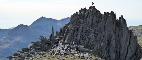
The two adjacent peaks in the middle of the Glyderau south-west of Tryfan are the highest: Glyder Fawr nudges 1001m, with Glyder Fach just to the east close behind at 994m. Between them is the pass at Bwlch y Ddwy Glyder and the vicious-looking pinnacles known as Castell y Gwynt (Castle of the Wind) on the south-west flank of Glyder Fach.
With numerous approach trails, there are countless possible combinations of circuits and traverses involving varying levels of scrambling.
A popular loop begins from Llyn Ogwen with a Tryfan summit, via the North Ridge or easier Heather Path. Continue over Glyder Fach, Bwlch y Ddwy Glyder and Glyder Fawr. Then descend north-west past Llyn y Cŵn and on to Cwm Idwal via Devil’s Kitchen and on to Idwal Cottage.
You could skip Tryfan and ascend Cwm Bochlwyd to Bwlch Tryfan, then continue south-west over the Glyders. Or head west from Llyn Ogwen to scale Y Garn (947m) and cut south-east to Llyn y Cŵn, climbing Glyder Fawr from the north.
An easier circuit approaches from the south, starting at Pen-y-Pass. This is less demanding and dramatic, but provides fabulous views back to Yr Wydff (Snowdon). Return from the eastern slopes of Glyder Fach via the Miner’s Track to the Pen-y-Gwryd Hotel which is famed as the base for Hillary’s team while training to conquer Everest.
For a much longer hike, you can also reach both Bwlch Tryfan and Glyder Fach from Capel Curig in the east, via Y Foel Goch.
Tryfan Circuit
Finally, if the weather isn’t good, or you’d just prefer a gentler walk, there are good alternatives. A low-level but lovely circuit around Tryfan provides views of the summit and ridge from all sides. From Idwal Cottage, skirt the north shore of Llyn Ogwen, then head south along the lower trail beneath and east of the Heather Terrace, then cross Bwlch Tryfan, descend through Llyn Bochlwyd and return to Idwal Cottage.
Explore more
We’ve got ideas for hundreds of wonderful walking routes across England, Scotland and Wales, long and short, easy and challenging. Search for routes on our website. Or join a guided walk with a local Ramblers group. Find your nearest Ramblers group and choose a walk that suits your pace, fitness and interests.
All images © Getty
The best routes to walk up Pen y Fan
Discover the finest paths up and around the tallest mountain of Bannau Brycheiniog (the Brecon Beacons).
The best routes to walk up and near Ben Nevis
How to tackle the formidable Ben Nevis, the UK’s highest mountain, and discover the best hikes close by too.
The ultimate guide to walking up Helvellyn via Striding Edge
How you can hike and scramble up the magnificent Helvellyn, one of the Lake District’s biggest and most iconic mountains.
Campaign with us
We campaign to remove barriers to walking and we step up to protect the places we love to wander.